

|
Friday Freebie Maps |

|
Every Friday I will post a new Creative Commons licensed map. You are free to use/print these maps for personal use only. If you wish to use any of these maps in a commercial or non-commercial product, please contact Tim Hartin to learn how.
Friday Freebies usually include two (sometimes more) versions of the same map. One has a white background (for easier printing) and the other has a darker background. Click on the images below to view the larger version of the maps or click on the year banners to view the maps for a particular year. Under the map images are notes about specific map details.
Friday November 27, 2015
|

Click on a year banner to view the maps for that particular year. |
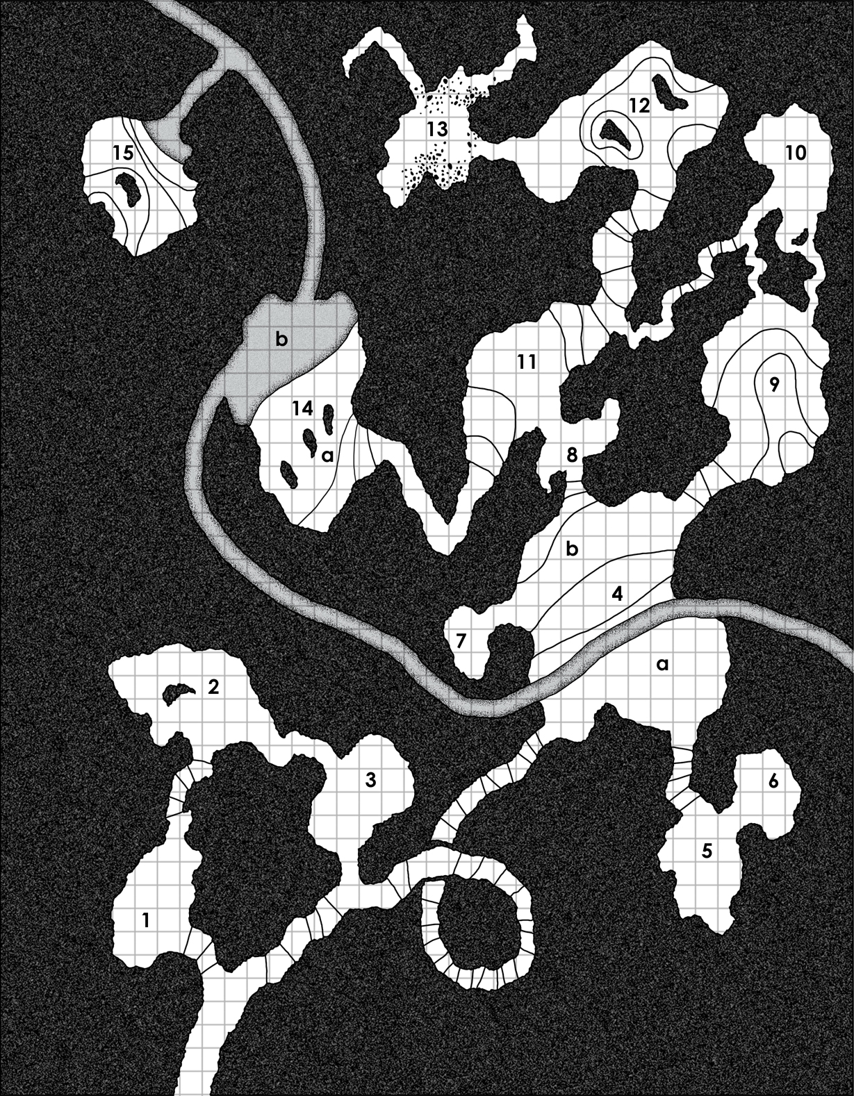
Map Details:
- The various lines throughout the caves are elevation lines.
- Areas 2, 10, 12, 14, and 15 have natural stone columns.
- An underground stream connects areas 4, 14, and 15. It is up to the DM if this stream is a regular tunnel or is completely submerged (a.k.a. an underwater tunnel).
- Area 13 has rubble.
Elevation Lines Notations:
- The water is flowing from top left to mid right. As for the "elevation lines", they represent a distance of anything from 1' to 5' (per line, there is no uniform distance since this is to represent the uneven floor of a natural cave system).
- Starting at the bottom of the map, the lines lead downwards (pretty straight forward at this point).
- Cave 4 has a slight hill in the centre (the two middle lines that flank the bottom and top of the number 4). The lines just above 4 b lead down to cave 8, as does the lines to the right lead down to cave 9.
- Caves 5 & 6 could be at a higher or lower elevation (whichever the DM chooses).
- Cave 9 has a hill in it. The most northern section of cave 9 is level with cave 10.
- The lines to the left of cave 11 lead up. The lines to the right lead down. The new lines in the side tunnel to cave 10 should align things up correctly.
- Cave 12 has two small mounds. The most northern and western line leads down.
- The lines of cave 14 lead downward (towards cave 11).
- The lines in cave 15 lead upwards from the watery entrance.

These maps by Tim Hartin are licensed under a Creative Commons Attribution-Noncommercial-Share Alike 2.5 Canada License. Inquiries about permissions beyond the scope of this license should be made by contacting Tim Hartin.